

Irrigation Channel Water Level Monitoring From Headworks to Farm Outlet


Key Takeaways
Measure at the structures that decide deliveries. Headworks, regulators, weirs, flumes and tail ends say more than a random point on the bank.
Keep the sensor out of the water. A non-contact radar mounted above the surface leaves weed, silt and floating debris with nothing to foul, and it can be fixed to a bridge, gantry or bracket arm.
Tie every level to a surveyed datum. A height only becomes useful for ordering, spill warnings and flow estimates when it is referenced to the crest, the bank and the channel bed.
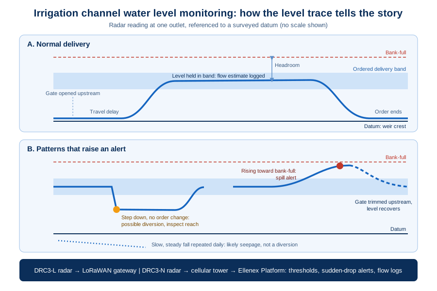
Alert on change as well as on height. A falling level with no order running, or a rise toward bank-full, is often the first sign of a diversion, a stuck gate or a coming spill.
Choose the network to match the canal. Clustered structures near a depot suit a private LoRaWAN gateway, while outlets strung along many miles of channel suit direct NB-IoT/LTE-M cellular.
An Irrigation Order Is a Promise Made Upstream and Kept Downstream
Every irrigation delivery starts as a request. A grower asks for water on a given day, an operator opens a gate at the headworks, and the water then has to travel the length of the channel before it reaches the farm outlet. Irrigation channel water level monitoring is how the people running that network find out whether the promise was kept: whether the right head of water arrived, whether it held, and whether any of it was lost along the way.
That matters because irrigation is the largest single user of fresh water. Agriculture accounts for about 70 percent of freshwater withdrawals worldwide. Much of it moves through open canals where nobody sees what happens between one gate and the next.
Ellenex addresses this with its Remote Irrigation Channel Water Level Monitoring solution, which pairs a battery-powered radar level sensor with either LoRaWAN or NB-IoT/LTE-M connectivity and the Ellenex Platform. The sensor sits above the water at a structure and reports surface height to a dashboard operators can check from anywhere.
Below, we follow the water from structure to dashboard. For the broader picture of how Ellenex approaches water networks, see its water infrastructure monitoring overview.
Lost Heads, Wet Roads and Arguments Over Every Delivery
When a channel runs without level data, problems are discovered by their consequences rather than by measurement:
Water spills at the tail end. If more water is released than downstream outlets take, the surplus runs out through escapes and drains. That water was already paid for, pumped or stored.
Downstream growers come up short. A head that looked right at the regulator can thin out by the time it reaches the last outlets, and the first sign is often a phone call from a farmer whose crop is waiting.
Unauthorized diversions go unnoticed. Pumps or siphons drawing from a channel between structures leave no trace in the delivery records, so the loss is absorbed by everyone else on the system.
Banks overtop and erode. A gate left open or a blocked culvert can raise a pool past bank-full, washing out tracks and weakening the embankment.
Billing and allocation disputes drag on. Without a record of what level was actually held at an outlet, operators and customers argue from memory instead of from evidence.
Canals Stretch Farther Than Any Patrol Can Watch
Measuring an open channel well is harder than it sounds, for reasons that come from the shape of the network itself:
The network is long and thin. A single scheme can run main channels, spurs and laterals across a large area, with structures spread far apart along dirt tracks.
Water takes time to arrive. A gate change at the headworks reaches downstream pools hours later, so a single spot check rarely shows the full effect of a decision.
Structures have no power or phone line. Regulators and drop structures are usually in open country, far from mains supply, cabling or a communications cabinet.
The surface is never clean. Weed, algae, silt, wind ripple and turbulence below a gate all work against anything that has to touch the water to measure it.
Mounting points are limited. Bridges, walkways, gantries and wing walls are often the only places to fix a sensor, and they belong to structures that cannot be modified casually.
The channel changes with the season. Channels sit dry or nearly empty for part of the year, then run full, and occasionally carry storm water they were never meant to hold.
Irrigation Channel Water Level Monitoring, Station by Station
The steps below follow one monitoring point from structure to phone alert, a pattern that repeats at every station.
Picking the Structures Worth Instrumenting
Not every stretch of channel needs a sensor. Readings carry the most value just downstream of the headworks, upstream of major regulators, at measuring structures such as weirs and flumes, at key farm outlets, and at the tail end where spills begin. As general practice, many operators start with the headworks and the tail end, because together they show what was released and what was left over.
Settling the Water Surface First
Where the surface is rough, a stilling well beside the channel gives a calmer reading. It is a short vertical pipe or chamber connected to the channel below the waterline, so the water inside rises and falls with the channel while waves and turbulence are damped out. Where the reach is calm and straight, the radar can look directly at the open water instead. Both are common in general hydrometric practice.
Fixing the Radar Above the Water
The sensor is mounted on a bracket, bridge rail or gantry so that it points straight down at the surface. It should have a clear view of the water, away from side walls, gate leaves and anything that might swing into the beam. The Ellenex radar uses a narrow beam, which helps it ignore nearby structure, and with nothing touching the water there is no probe to clean or bury in silt.
Turning an Echo Into a Water Height
The sensor sends a high-frequency radar signal down to the surface and times the reflection that comes back. That gives the distance from the sensor to the water. The transmitter then converts this into the quantity operators actually care about: the height of water above the channel bed or the weir crest, and the headroom left before the water reaches bank-full.
Anchoring Readings to a Surveyed Datum
A level is only meaningful when everyone agrees where zero is. As general practice, the mounting height is surveyed against the structure's crest, the channel invert and the top of bank, and those references are entered on the Platform. Readings then compare directly with design levels, and a replacement sensor continues the same record.
From Water Height to Estimated Flow
At a weir, flume or a well-defined channel section, there is a known relationship between how high the water stands and how much is passing. The Ellenex solution datasheet lists estimated volumetric flow from weir or flume rating curves as one of the telemetry outputs, alongside water level and bank-full margin. That lets one sensor provide both a level and a running flow record for the structure.
Reading, Sending and Saving Battery
Each sensor runs from an internal replaceable lithium battery, with external power available as an option. Ellenex quotes that battery's capacity as a total of sensor readings plus radio transmissions, never as years of service, which means its service life is set by the measuring and reporting schedule you choose. The sampling interval can be changed remotely, and the LoRaWAN model can also be set to transmit when a reading crosses a condition rather than on every sample.
Two Ways Off the Channel Bank
With DRC3-L, readings travel by LoRaWAN to an outdoor gateway at a depot or high point. From there, a network server confirms each sensor's identity, unlocks the encrypted message and drops repeated copies. With DRC3-N, readings use NB-IoT/LTE-M to reach a nearby cellular tower directly, so no gateway is needed. Both routes carry encrypted data. For a fuller comparison of the two networks, read the Ellenex guide to LoRaWAN and NB-IoT on industrial sites.
Where the Platform Turns Levels Into Decisions
On the Ellenex software platform, each station appears with its current level, headroom, estimated flow, battery state and signal strength. High and low thresholds, sudden-drop alerts and historical flow logs sit alongside the live view, and alerts can reach several people through more than one channel. The same dashboards are available in a browser at ellenex.net and on phones via the Ellenex mobile app.
Ditch Riders Spend Their Day on Exceptions, Not Rounds
Once the main structures report on their own, the daily pattern of running a channel network shifts:
The first check is a screen, not a drive. Operators review every station before leaving the depot and send people only where a reading looks wrong.
Orders can be confirmed downstream. When a delivery is released, the level at the receiving outlet shows when it arrived and whether it held.
Spills are caught while they are still small. A rising tail-end level prompts a gate adjustment upstream before the surplus runs out through the escape.
Overnight losses leave a record. A pool that falls when no orders are running stands out on the trend line and points to a diversion, a leaking gate or seepage.
Conversations with customers start from data. A shared level history replaces competing recollections of what was delivered.
The Dividend From Knowing Where the Water Is
The return from channel level data shows up in many small savings rather than one headline number. For a structured way to weigh these benefits against deployment cost, see the Ellenex article on the financials of IoT implementation.
Patrol Miles Swapped for Targeted Visits
Staff no longer drive the full length of a channel to read staff gauges. Trips are made to fix something, not to find out whether something needs fixing.
Released Water That Reaches a Paying Outlet
Tighter control of how much is released, and earlier warning of spills, means more of the water that leaves the headworks ends up on crops instead of in a drain. Cutting those losses is one of the core aims of water infrastructure monitoring across any delivery network.
Banks, Gates and Access Tracks Spared From Overtopping
Catching a rising pool before it reaches bank-full protects embankments, structures and roads from the erosion and repair work that follows an overflow.
Fewer Night Callouts Along Remote Banks
Checking a level in the dark or in a storm carries real risk, and remote readings make those trips rarer.
Delivery Schedules Built on the Network's Real Behavior
A season of level and flow history shows travel times, leaky pools and chronically short outlets, so schedules rest on evidence.
A Light Installation Footprint
The sensors are battery-powered and pre-configured, so there is no trenching for power or cable, and a station can be added to an existing structure without civil works.
Evidence for Upgrades and Allocation Decisions
Long-term records help justify lining a leaking reach, rebuilding a structure or changing how allocation is shared, and they give regulators and customers something concrete to review.
Each Canal Headache, Paired With a Radar Answer
Distance Between Structures
Each station reports on its own, so the length of the network no longer limits how often it is checked. DRC3-L and DRC3-N both carry their own battery and communicate wirelessly, which suits structures miles apart.
Rough or Fouled Water Surfaces
Because the radar is non-contact and measures from above, weed, algae and silt have nothing to grip. The sensor head and enclosure are rated to be fully submersible and weather-sealed, with UV protection, so a reach that briefly floods over the sensor does not end its life.
No Power or Communications at the Structure
The internal battery and the choice of two wireless routes remove the need for mains supply or a cabled link. Optional external power is available where a site already has a DC supply.
Water That Takes Hours to Arrive
Stored readings show a delivery's whole journey, from release at the headworks to arrival at each outlet.
Clustered Structures Versus Scattered Outlets
Where several regulators, a weir and a depot sit within reach of one another, a private LoRaWAN gateway can serve them all with no recurring airtime charges, and DRC3-L is the natural fit. Where outlets are strung along a long main channel, or spread across separate schemes, DRC3-N connects each one directly through the cellular network, so coverage follows the public network rather than a gateway's reach.
Seasonal Shutdowns and Restarts
Sampling and reporting can be adjusted remotely, so a station can report sparingly while the channel is dry and more often once deliveries resume, without anyone visiting the site.
Ellenex for Irrigation Channels: Mechanism and Outcome
Mechanism
A non-contact radar level sensor mounted above the water at a structure measures the distance to the surface and converts it to water level and bank-full headroom.
The Remote Irrigation Channel Water Level Monitoring solution offers a LoRaWAN version through a pre-configured outdoor gateway and an NB-IoT/LTE-M version direct to the cellular network.
Encrypted readings reach the Ellenex Platform, which applies rating curves for flow estimates, stores history and manages thresholds and alerts.
Outcome
Operators see level, headroom and estimated flow for every instrumented structure from one dashboard.
Spills, short deliveries and unexplained drops are flagged while they can still be corrected.
A continuous record supports delivery planning, customer conversations and investment decisions.
Sending Channel Readings to Ordering, SCADA and Reporting Systems
Many irrigation operators already run a water ordering system, a SCADA platform for gated structures, or a spreadsheet-based allocation process. Level data is most useful when it reaches those tools rather than sitting in a separate screen.
The Ellenex Platform provides an open API, webhooks and data export, so readings can be pushed into SCADA, ERP or ordering systems, or pulled into a reporting tool on a schedule. Role-based access lets an operator give field staff, managers and contractors different views of the same network. For the LoRaWAN version, the DRC3-L datasheet also notes that the sensor can be configured to work with major third-party network servers, which helps where a district already runs its own LoRaWAN infrastructure.
As general practice, map each sensor to the name its structure already carries in your existing systems, so readings land against the right regulator or outlet. Pairing channel levels with other data on the same farm, such as soil moisture monitoring or pressure monitoring in irrigation systems on pressurized laterals, gives a fuller picture of where delivered water actually goes. Where a scheme also draws on bores, remote ground water level monitoring completes the view of the supply.
Canal Monitoring Beliefs Worth Testing
A staff gauge read once a day is close enough. A daily reading misses whatever happens between visits, including overnight diversions and short spill events. A continuous record shows the timing and duration of each change.
Weed and debris make sensors useless in open channels. That is a real problem for anything immersed in the water. A radar mounted above the surface measures without contact, so fouling of the sensing element is not part of the picture.
Wireless sensors need a tower on every structure. NB-IoT/LTE-M sensors use existing cellular coverage, and a single LoRaWAN gateway at a high point can cover a cluster of nearby structures.
A Delivery Network That Accounts for Its Own Water
When each important structure reports its own level, an irrigation network stops being something that has to be patrolled to be understood. Operators can see a delivery leave the headworks and arrive at the outlet, notice a falling pool before a grower calls, and adjust a gate before water reaches the escape. Over a season, the readings become a record that supports fairer allocation and stronger cases for repairs. That is the practical promise of infrastructure monitoring for open channels: less guesswork, fewer wasted trips and more of the released water reaching the crops it was meant for.
Frequently Asked Questions
Why is water lost in irrigation channels, and where does it go?
Open irrigation channels lose water in several ways between the headworks and the farm outlet. Seepage through unlined beds and banks is often the largest share, particularly in sandy soils or older earthen channels. Evaporation takes more from wide, shallow reaches in hot, windy weather. Operational losses add to that: water released ahead of demand that ends up spilling through escapes at the tail end, gates that leak or are left open, and outlets that take more than was ordered. Unauthorized diversions by pumps or siphons drawing between structures are another loss that rarely appears in delivery records. Because most of these losses happen out of sight along long stretches of channel, operators often know that water is missing without knowing where or when it went.
Measuring level at the structures that control deliveries is the first step to finding those losses. The Ellenex Remote Irrigation Channel Water Level Monitoring solution places a battery-powered radar level sensor above the water at headworks, regulators, weirs, outlets and tail ends, and reports each reading to the Ellenex Platform. A pool that falls when no orders are running points to seepage, a leaking gate or a diversion, while a rising tail-end level warns that a spill is about to begin. With history building at every station, operators can see which reaches lose the most water and direct repairs and patrols there.
How is water level measured in an open irrigation channel?
Several methods are in common use. The simplest is a staff gauge, a marked board fixed in the channel that someone reads by eye, which is cheap but only as frequent as the visits. Float systems in stilling wells and submerged pressure sensors provide continuous readings, but both sit in the water, where weed, algae and silt can foul them and floods can bury or damage them. Non-contact sensors, such as radar and ultrasonic devices, measure from above by timing a signal reflected from the water surface. Radar is widely favored for outdoor channels because, unlike ultrasonic sensing, its signal is largely unaffected by changes in air temperature, and it has no parts in the water to maintain.
Ellenex uses non-contact radar for this application. The DRC3-L and DRC3-N sensors mount on a bracket, bridge rail or gantry and look straight down at the surface with a narrow beam that helps them ignore nearby structure. They time the reflection from the water to find the distance, then convert it to water height above the bed or weir crest and the headroom left before bank-full. The sensor head and enclosure are weather-sealed with UV protection and rated to be fully submersible, so a reach that briefly floods over the sensor does not end its service.
How can level readings be used to estimate flow in a channel?
Water level and flow are linked wherever the channel has a known control, such as a weir, a flume or a stable, well-defined section. At these structures, hydraulic theory and field calibration produce a rating curve that relates the height of water to the volume passing per unit of time. Once the rating is established and the level sensor is referenced to the correct datum, usually the weir crest or channel invert, every level reading can be converted into an estimated flow. The accuracy of that estimate depends on the structure being kept clean and in good condition, on the rating being checked periodically, and on the sensor's zero being tied to a surveyed reference that survives sensor replacement.
The Ellenex solution datasheet lists estimated volumetric flow from weir or flume rating curves as one of the telemetry outputs, alongside water level and bank-full margin. That means a single radar station at a measuring structure can provide both a live level and a running flow record on the Ellenex Software Platform. Historical flow logs, high and low thresholds and sudden-drop alerts sit together in the same view, so operators can see how much water passed a structure during a delivery and compare it with what was ordered further downstream.
How does remote monitoring improve water delivery to farms?
Delivering water on time and in the right amount is difficult when operators only see a channel during patrols. A gate change at the headworks can take hours to reach downstream outlets, so without readings along the way, staff often release extra water as a safety margin, which then spills at the tail end. Growers at the far end of a channel may receive less than they ordered, and the first sign is often their phone call. Remote level data replaces that guesswork with a view of the whole delivery: when water left the headworks, when it reached each outlet, whether the head held, and how much was left over at the end.
With Ellenex radar stations on the key structures, the first check of the day becomes a dashboard rather than a drive. The Ellenex Platform shows level, headroom and estimated flow for each station, and alerts can reach several people by more than one channel when a pool falls unexpectedly or rises toward bank-full. Readings can also be pushed into water ordering, SCADA or reporting systems through an open API, webhooks and data export, so the level at each outlet sits beside the order it was meant to fulfil. Over a season, that history shows travel times and chronically short outlets, helping operators plan releases more precisely.
Can channel level data help resolve disputes over water allocation and billing?
Disputes over irrigation deliveries are common because both sides usually argue from memory or from incomplete records. A grower may believe an order arrived late or short, while the operator believes the release was correct, and without a measured record at the outlet neither can prove their case. Unexplained losses between structures, including possible unauthorized take, are also hard to address without evidence of when and where levels changed. A continuous, time-stamped level record at the relevant structures turns those conversations into a review of data, which is faster, fairer and less damaging to the relationship between the scheme and its customers.
Ellenex radar sensors build that record automatically, with each reading tied to a surveyed datum so levels can be compared with design values and with readings at other structures. The Ellenex Platform stores the history, supports data export for reports, and uses role-based access so operators can share appropriate views with managers, contractors or customers. Where flow is estimated at weirs or flumes, the same record shows how much water passed during each delivery. For schemes that also draw on bores, adding remote ground water level monitoring gives a fuller account of the supply behind every allocation decision.
Related Reading
Precise Irrigation: Ellenex Radar Level Monitoring Solutions for Agriculture Water Channels: an earlier look at radar level sensing for farm water channels and its benefits for crop yield.
A River Flood Monitoring System Should Warn on Rate of Rise, Not Just Height: how the same radar approach supports early flood warnings on rivers.
Why Bore Drawdown Monitoring Spots Trouble Before the Pump Does: monitoring the groundwater side of an irrigation supply.
Sensors Unleashed: A Guide to Ultrasonic, Radar and Submersible Tech: choosing between level sensing technologies for different assets.
Useful Links
Talk to Ellenex
A trial on a single channel, from headworks to tail end, is often enough to show where water goes missing and where it spills. The Ellenex team can help choose which structures to instrument, which connectivity route suits each reach and how readings could flow into the systems your operators already use. Begin through the Ellenex sales inquiry page with a rough map of the channel and the outlets that give you the most trouble.


