

A River Flood Monitoring System Should Warn on Rate of Rise, Not Just Height


Key Takeaways
Watch the slope as well as the height. A rate-of-rise alert fires while the river is still below its high-water line, which is where most of the useful lead time sits.
Fix the level datum once and write it down. Every reading, alert threshold and later sensor swap depends on one fixed reference point.
Look down at the water instead of standing in it. A non-contact radar head mounted above the channel stays clear of debris, mud and growth that wreck submerged probes.
Match the network to the river's geography. A private LoRaWAN gateway fits reaches that sit close together, and cellular NB-IoT or LTE-M fits lone sites scattered along a catchment.
Treat thresholds as living settings. Start cautiously, review them after each rise and let the Platform carry the changes to every site.
A Warning Is Only as Good as the Hours Behind It
A river flood monitoring system exists to buy time. It measures the surface of the water continuously, notices how fast that surface is climbing and tells the right person while there is still room to act: close a road, open a gate, move a crew, call a neighbor downstream. The Ellenex flood monitoring on rivers solution is built around that single job, using a battery-powered radar level transmitter that looks down at the water from above.
Wired river gauging works where there is power and a road. Most of a catchment has neither, and the people responsible for remote culverts and low bridges often learn about a rise from a phone call instead of a reading.
Remote monitoring closes that gap. Instead of someone driving out to read a staff gauge, the sensor reports on a schedule, speeds up its reporting when the river behaves oddly and sends an alert the moment a threshold is crossed. The Ellenex Platform then keeps the history, so a council or utility can see how each storm played out.
For a field example, see our earlier story on river flood monitoring tied into a road alarm system, and for the product-design side of the same family of sensors, read our look at LPWAN-operated flood monitoring features. This post takes a different angle: how to design the warning itself, as one piece of water infrastructure monitoring across a catchment.
Floods Without a Gauge: Late Calls, Closed Roads, Lost Trust
Warnings that arrive after the water does. When the first signal is a resident's phone call, response begins with the river already over its bank and every minute of lead time spent.
Roads and crossings closed too late or too early. Without a live reading, authorities either wait for evidence and risk vehicles in water, or close routes on suspicion and strand people for no reason.
Crews sent into fast water to find out what is happening. Reading a staff gauge during a storm puts people on slick banks and flooded access tracks at exactly the wrong moment.
Gates, pumps and diversion works operated blind. Flood-control equipment that cannot see the river is run on schedule or on habit, which wastes capacity when it is needed and wears equipment when it is not.
Rivers Make Honest Measurement Awkward
Banks that are far from power and roads. The best measuring points are often the least accessible, so any sensor that needs mains, trenching or frequent visits is a poor fit.
Water that carries things. Silt, leaves, branches and algae foul anything submerged, and a flood pulse can deliver all of it at once.
Levels that change by large amounts, quickly. A reach that sits calm for weeks can climb dramatically in a single storm, so the sensor must cope with the whole range and the speed of change.
Structures that confuse a beam. Bridge piers, ledges, vegetation and wing walls can return echoes that have nothing to do with the water surface.
Weather that attacks hardware. Sun, frost, spray and wind all work on an enclosure over years of exposure.
A reference point that quietly moves. Without a recorded benchmark, a replaced sensor or shifted bracket makes history impossible to compare.
River Flood Monitoring System Anatomy: From Radar Echo to Rising Alarm
A river flood monitoring system is a short chain with a lot of care in each link. The stages below follow one reading from the moment the radar looks at the water to the moment someone receives a warning.
Echoes Off Moving Water Give the Distance Down to the Surface
The radar head sends a narrow beam toward the water and times the echo that returns from the surface. Because nothing touches the river, there is no probe to be buried in silt, snagged by branches or coated by growth. What the sensor reports is a distance from the head to the water.
Turning Distance Into Stage Above a Fixed Datum
A distance is not yet a river level. The head sits at a known height above a surveyed reference, the datum, and stage is the height of the water above that reference, worked out from the mounting height and the measured distance. It only stays correct if the mounting height and the datum are recorded when the sensor goes in.
Rate of Rise Tells You What Height Alone Cannot
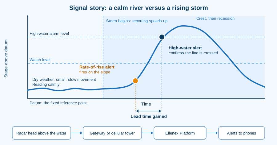
A fixed high-water alert answers one question: has the river reached a line? A rate-of-rise alert answers a better one: how quickly is it getting there? A river climbing steeply from a low base can be more dangerous, and give far less time, than one that is slowly creeping toward the same line.
For that reason a useful river setup carries both kinds of alert. The steep-slope alert is the early one, the high-water alert is the confirming one, and the gap between them is the lead time the system was installed to create.
Bridge, Arm or Gantry: Where the Head Looks Down
The radar head goes above the water, on a bridge, a mounting arm or a purpose-built gantry, with its beam aimed at open water and clear of piers, ledges and overhanging branches. It also has to sit above the highest level the river is expected to reach, or the sensor would be measuring its own flood.
This is general practice rather than an Ellenex procedure: choose the mounting point on a dry-weather visit, aim the head squarely at the channel, and keep it away from vertical walls that can bounce the beam. Ellenex units arrive pre-configured for the Platform, so the work at the bank is mechanical rather than programming.
Reading Calmly Now, Reporting Urgently When It Matters
Battery life and warning speed pull in opposite directions. Reading and sending constantly would drain the cell, while reading rarely would miss the rise. The transmitter resolves this with a sampling interval that can be configured and with event-triggered behavior, so it can take readings at a relaxed pace in dry weather and respond more actively when conditions change.
Radio to a Local Gateway, or Cellular Straight to the Tower
The LoRaWAN variant transmits over sub-GHz radio. An Ellenex outdoor gateway receives the radio signal and relays the reading through the network server to the Platform. Cellular units skip the gateway entirely: they connect to the carrier's tower through NB-IoT or LTE-M using a pre-configured SIM, and the data then reaches the Platform.
For more on the two families, see our knowledge-centre explainers on LoRaWAN and on NB-IoT and LTE-M. The short version: a gateway pays off where several sites sit within radio reach of one another, and direct cellular pays off where sites are scattered and a gateway would serve only one.
From Stage Reading to Warning Message on the Platform
On arrival, the reading is stored, plotted against earlier readings and compared with each configured threshold. Alerts go to the people named in the setup, history builds into a record of every rise, and the data can flow onward through an API or into SCADA and civil defense systems. The Ellenex Software Platform and the Ellenex Mobile App give crews a live view without needing a control-room desk.
Duty Officers Who Watch a Curve Instead of Driving to a Gauge
The first sign of trouble is a trend, not a phone call. A steep line on a dashboard shows a problem developing while the river is still inside its channel.
Site visits follow need instead of the calendar. Routine gauge-reading trips give way to visits triggered by a real alert or a maintenance flag.
One view covers the whole catchment. Instead of ringing around, an officer opens a single screen and sees which reaches are rising, steady or silent.
Warnings reach the people who can act. Thresholds are tied to named contacts, so the road crew, the gate operator and the emergency desk each hear what concerns them.
Every storm adds to a growing record. Each event leaves a clean stage history that sharpens the next set of thresholds.
Quiet sites stay visible. A sensor that stops reporting is itself a signal, so a dead battery or a damaged bracket gets noticed rather than discovered at the worst moment.
Weighing What Early Warning Is Worth to a Council or Utility
Early warning pays back, and it belongs to the wider practice of infrastructure monitoring. For a framework to set the numbers against your own situation, Ellenex has a financial case for IoT implementation that walks through the principles.
Fewer Drives to Gauges in Rising Water
Every reading that arrives on its own is a trip that does not need to happen. Over a wet season, that adds up to a large number of avoided drives along flooded or damaged access roads.
Road Closures Timed to Real Conditions
With a live river level, closures follow measured conditions. Roads stay open while it is safe and close promptly when it is not, which is better for traffic and for public confidence.
Floodgates and Pumps Operated on Evidence
Where structures can be operated in response to river levels, a continuous reading lets operators act on what the river is doing instead of a fixed schedule, protecting capacity and equipment alike.
Field Crews Kept Out of Fast Water
Reading a gauge by hand during a storm is the riskiest version of the job. Moving that task to a sensor takes people out of the one place they should not be.
Warnings Issued With Confidence, Not Hunches
A warning backed by a clear rate-of-rise trace is easier to justify, easier to communicate and easier to defend afterward than one based on a single observation.
Light Installs Without Trenching or Mains
A battery-powered unit on an existing bridge or arm avoids cable runs, civil works and power connections. That brings river points within reach that a wired design would never justify.
A Stage Record for Design and Post-Event Review
Continuous history supports culvert sizing, flood modeling, funding applications and honest reviews of how a response went.
Meeting Each River Challenge With DRC3-L or DRC3-N
The flood monitoring on rivers solution is built on two transmitters. The DRC3-L is the LoRaWAN variant and the DRC3-N is the NB-IoT and LTE-M variant. They share the same radar-based, low-power, corrosion-resistant design and differ in how the reading leaves the bank.
Debris, Mud and Algae Stay Out of the Measurement
Because the head never touches the water, there is nothing submerged to foul, bury or snag. The DRC3-L product page and the DRC3-N product page both list flood alarming as a core use.
Sealed, Sun-Stable Housings for Open Banks
Both transmitters sit in a fully sealed, UV-protected enclosure built for outdoor and underground use. That matters on an exposed bridge where sun, spray and weather are constants.
How Reporting Habits Decide Battery Capacity on a River Site
Battery capacity on a transmitter like this is rated in readings and in transmissions, not in calendar years, and the real-world figure depends on how often the unit reads and how often it sends. A river site that reports calmly in dry weather and more actively during storms will stretch a battery further than one that transmits at a constant high rate. The battery is replaceable, and external power is an option where it is available.
Thresholds and Rate-of-Rise Alerts That Reach the Right Phone
High-water and rate-of-rise alerts are set on the Platform, along with sampling and transmission settings. The cellular variant lets high and low alarm thresholds, sampling intervals and transmission conditions be configured there, and the LoRaWAN variant can be tuned by downlink or locally over a wireless connection, including event-triggered sampling and conditional transmission.
Gateway Clusters Along a Valley, Cellular for Remote Reaches
Where several river points sit within radio reach of each other, a private LoRaWAN gateway links them without per-site subscriptions. Where points are scattered, with a culvert here and a bridge many miles away, the cellular variant reports straight to the tower with no gateway to build or power. A single catchment can use both.
Open Hand-Off to SCADA and Civil Defense Systems
The solution works with the Ellenex Platform and can also connect to third-party LoRaWAN network servers, SCADA and civil defense systems. The cellular variant works with common protocols including UDP, LwM2M, MQTT and NIDD, and telemetry is encrypted along the way.
How the Ellenex Package Turns Echo Into Action
Mechanism: a radar head looks down at the water from a bridge or arm, the transmitter works out stage above the datum, and the unit reports on a configurable schedule or when an event triggers it.
Outcome: a continuous, trustworthy river record with a warning that fires on rise as well as on height.
Mechanism: the LoRaWAN route uses an Ellenex outdoor gateway and network server; the cellular route uses NB-IoT or LTE-M straight to the tower with a pre-configured SIM.
Outcome: the connectivity fits the geography of the river instead of forcing the river to fit the network.
Mechanism: the Ellenex Platform stores readings, compares them with thresholds and passes alerts and data on through its API and integrations.
Outcome: the right person hears about a rise early, and the record builds into a reference for the next season.
A River Stage Glossary Without the Jargon
Stage: the height of the water surface above a fixed reference, which is the number most flood warnings use.
Datum: the surveyed reference point that every stage reading is measured against. It must stay fixed or be documented when it changes.
Rate of rise: how quickly stage is increasing, usually the earliest sign that a storm is feeding the river.
Bankfull: the level at which water reaches the top of the channel and is about to spill onto the floodplain.
Siting Slips That Distort a River Record
A beam that clips a pier or ledge. The echo from structure can be mistaken for the water, so aim the head at open water and walk the line of the beam.
A head mounted too low. A sensor that the flood can reach measures its own mounting, so clearing the highest expected level matters more than convenience.
An unrecorded datum. Without a surveyed reference noted at installation, a swapped sensor or bent bracket silently shifts the whole record.
Thresholds copied from another river. A reach with a fast, flashy response needs different settings from a slow lowland channel, so set each site from its own early readings.
Silence treated as safety. A site that has stopped reporting is a problem to chase, not proof that the river is calm.
A Valley Where the River Speaks First
When a river flood monitoring system is working, the river tells people what it is doing before the damage begins. It also links to the rest of a water infrastructure monitoring network: the same river often feeds the storm water level monitoring of drains beneath a town, the rain level monitoring that explains a rise and the dam and water resource level monitoring upstream. Rates of rise show up as steep lines, warnings reach named phones, and crews head out because a reading asked them to rather than because a storm trapped them.
Frequently Asked Questions
Can a radar sensor read a river with waves, foam or floating debris on the surface?
A radar head measures the distance to the surface from above, so moving water, foam and drifting material do not foul it the way they foul submerged probes. Surface texture can add some variation to individual readings, which is why a continuous record and a sensible reporting interval are more useful than any single sample.
Review the first storm's trace to see whether thresholds need a margin for surface noise.
How high above the water should the sensor sit, and does it need to clear the flood peak?
The head must sit above the highest level the river is expected to reach, with enough clearance that the beam keeps a clean view of the surface across the whole range. Beyond that, the right height depends on the structure and the sensor's measuring range, so the choice is made against the bridge or arm that is actually available.
Ellenex offers several measuring ranges and configuration choices, and the team can help match one to a site.
What is a level datum and why does it matter when the sensor is later replaced?
A datum is the fixed reference against which stage is measured. The sensor reports distance, and stage is worked out from the mounting height above the datum, so the datum is what makes readings comparable across years.
When a sensor is replaced or a bracket is adjusted, the new mounting height is entered against the same datum. The history then carries on without a step in the record that nobody can explain.
How do I set the first warning thresholds on a river with no logged history?
Begin with local knowledge: the level at which a particular crossing becomes unsafe, the line where water leaves the channel and the points that observers already recognize. Set a watch threshold below each of those and a firm alarm at the level that demands action.
Then let the first few rises refine the numbers, especially the rate-of-rise setting.
How fast can a rate-of-rise alert reach a phone when the river is climbing?
Alert speed depends on how often the transmitter reads and reports and on the network that carries the message. A unit configured to speed up when conditions change can raise a warning promptly, while a unit that reads and sends only occasionally will naturally be slower.
For that reason the reporting behavior should be chosen with the warning in mind, not only the battery. Both variants allow event-triggered sampling and conditional transmission, and the cellular variant adds alarm thresholds configured on the Platform.
What if there is no mains power or phone line near the bank?
That is the situation the solution is designed for. The transmitters run on a replaceable battery with external power as an option, and the cellular variant reports directly to the tower while the LoRaWAN variant reports by radio to a gateway.
Where a gateway is needed, it must be installed with power and backhaul, so a site plan should settle that early.
Can several river sites feed one warning view shared with a neighboring council?
Yes. The Platform collects readings from every site in one place and can pass data to other systems through its API and integrations, including civil defense systems.
Sharing is best set up with clear permissions, so a neighboring authority can see the stage and alerts for a shared river without gaining control of settings.
Related Reading
Safeguarding Communities by River Flood Monitoring Integration to Road Alarming System: river readings tied to road warnings.
Unique Product Features With Enhancement in LPWAN Operated Flood Monitoring Solutions: the DRC3 sensor family's design.
Reliable and Cost Effective River and Waterway Level Monitoring: both network options on waterways.
Case Study: From Droughts to Deluges, Melbourne's Flood Monitoring Gets Smarter: a city example across dry and wet extremes.
Useful Links
Talk to Ellenex
Somewhere along your river is the reach that rises fastest and is watched least. Tell the team where it is, what crosses it and who needs the first warning through the Ellenex sales inquiry page, and they will help match a sensor, a network and a first set of thresholds to it.


