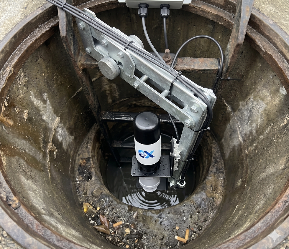
Safeguarding Communities by River Flood Monitoring Integration to Road Alarming System

Success for flood monitoring sensor, which talks to the road signs directly without any human interference.
Flood alerting is an essential safety feature for smart road and cities. Automated flood alerting based on the advanced LPWAN technologies increase the intelligence with fraction of the old fashion technologies.
The paradigm of modern disaster management has shifted decisively from a reactive posture toward a proactive, intelligence-driven framework. As global climate patterns exhibit increasing volatility, manifested in the rising frequency of extreme hydrological events, the imperative for robust infrastructure monitoring has never been more acute. Municipal authorities and industrial operators are now tasked with managing complex, geographically dispersed assets that are vulnerable to the devastating impacts of riverine flooding and structural degradation. At the intersection of public safety and civil engineering, the integration of high-precision sensing technology with Low-Power Wide-Area Network (LPWAN) connectivity represents a transformative leap in our ability to safeguard human life and critical assets.

The central challenge in flood mitigation has historically been the latency and unreliability of data acquisition. Legacy monitoring systems often relied on manual observations or bulky, expensive equipment that lacked the real-time visibility required for rapid emergency response. In high-risk environments where minutes can dictate the difference between safety and catastrophe, the transition to automated perception networks—exemplified by the deployment of the Ellenex Radar Sensor DRC3—is essential. These systems not only provide near real-time visibility into rising water levels but also enable automated, human-free interventions, such as the direct activation of roadside warning signage to prevent motorists from entering hazardous floodwaters.
The Criticality of Infrastructure Monitoring in Flood Resilience
Infrastructure monitoring is a multi-disciplinary field that leverages connected sensors and advanced analytics to track the health, performance, and availability of back-end components in real-time. For water-related assets, this discipline focuses on the components that regulate flow, storage, and treatment, including dams, reservoirs, pipelines, and bridges. The objective is to convert static structures into a monitored, intelligent layer that supports early intervention, reduces operational loss, and enhances long-term resilience.
The importance of this visibility is underscored by the four core outcomes it facilitates: improved resilience against environmental shocks, enhanced maintenance efficiency through condition-based prioritization, support for regulatory compliance and legal defensibility, and data-driven capital planning. Without continuous monitoring solutions, municipalities remain blind to the subtle precursors of failure, such as the gradual scour of bridge foundations or the slow accumulation of pressure in aging dams.
Comparative Impact of Automated Monitoring Implementations
Performance Indicator | Pre-Implementation (Legacy) | Post-Implementation (IIoT) |
Data Transmission Frequency | Daily/Weekly (Manual) | Near Real-Time (Every few hours) |
Emergency Alert Latency | > 2 Hours | < 10 Minutes |
Forecasting Accuracy | 70 - 80% | > 90% |
Maintenance Approach | Schedule-Based (Inefficient) | Condition-Based (Predictive) |
Annual Operational Expenditure | High (Frequent Inspections) | Low (Reduced Site Visits) |
Flood Monitoring and Road Safety
Road and urban flood monitoring systems are essential tools for local authorities in managing transit safety during severe weather. The direct interface between the DRC3 sensor and roadside electronic signs represents a significant leap in "Smart City" infrastructure.
Enhancing Driver Behavior Through Real-Time Alerting
The primary cause of vehicle-related flood deaths is the driver's inability to accurately assess the danger. Floodwaters can obscure washouts, hide debris, or exert lateral force sufficient to sweep a vehicle off the road. Automated alerting provides immediate, unambiguous guidance:
Real-Time Visualization: Motorists can access sensor data via council dashboards, allowing them to redirect their routes before encountering the water.
Immediate Response: Direct sensor-to-sign communication removes the "human delay," activating warning lights (WigWags) the instant water reaches a dangerous level.
Reduced Risk for Rescuers: By preventing motorists from entering floodwaters, these systems drastically reduce the number of high-risk water rescues required by emergency services.
Infrastructure Longevity and Economic Stability
Flooding does not just threaten lives; it destroys the pavement, sub-base, and drainage structures that comprise the road network. By monitoring levels and providing early warnings, authorities can redirect heavy traffic away from vulnerable saturated roads, preventing premature pavement failure and bridge damage. The cost of repairing a bridge after a washout can reach billions; the cost of a monitoring network is a fraction of that, offering a massive return on investment.
Success Story: The Queensland Automated Flood Resilience Project
A compelling demonstration of this technology's efficacy is the cooperation between Ellenex and a local council authority in Queensland, Australia. Queensland is a region characterized by intense tropical weather and rapid-onset "flash floods" that frequently submerge critical road crossings. The primary challenge faced by the council was protecting motorists from these unpredictable events, as driving into floodwater remains the number one cause of flood-related fatalities in the state.
The Challenge of Legacy Infrastructure
Before the implementation of the Ellenex solution, the council relied on static warning signs and manual inspections. During storm events, crews had to be dispatched in hazardous conditions to physically place barriers or activate signs. This approach was plagued by high operational costs, significant time delays, and an inability to provide real-time status updates to the public. The council required a low-cost, automated system that could bridge the gap between water level detection and motorist alerting.

The Solution: Direct Sensor-to-Sign Automation
To address this, a network of Ellenex sensors—initially trialed with ultrasonic models and subsequently upgraded to radar-based DRC3 units for enhanced reliability during storm conditions—was deployed along the riverside and at key state road crossings. These sensors were integrated with the Flooded Road Smart Warning System (FRSWS), an award-winning initiative that utilizes LPWAN technology to automate road safety.
A distinguishing feature of this solution is the customized relay output within the Ellenex hardware. This allows the sensor to communicate directly with electronic roadside signage (often referred to as "WigWags" or electronic warning boards) without the need for human intervention or even a centralized cloud connection to be active at the moment of activation. This provides a critical fail-safe: should the main network experience a disconnection due to catastrophic weather, the local link between the radar sensor and the warning sign remains operational, ensuring the alerting system never experiences a risk of disruption when it is needed most.
Success Outcomes and Expansion
The implementation was a resounding success. During severe weather events, including Ex-Tropical Cyclone Debbie, the automated system successfully kept vehicles out of floodwaters at every site where the sensors and signs were installed. The real-time data collected was also streamed to the council’s disaster dashboard, providing the community with live information about road status and river height.
The project, supported by the Queensland Reconstruction Authority and the Australian Government, has since been expanded with millions of dollars in funding to install hundreds of new automated assets across southern Queensland. This model of low-cost, high-reliability monitoring is now being shared as a success story for other councils in Australia, the United States, and Europe to build a safer future.
Solution Deep Dive 1: Flood Monitoring on Rivers
The Ellenex river flood monitoring solution utilizes the DRC3 radar sensor and LPWAN technology to provide a comprehensive perception network for municipal and industrial authorities. This "plug-and-play" system is designed to eliminate the complexities of traditional telemetry while offering industrial-grade durability.
Architecture of a Modern River Monitoring System
Sensor Deployment: DRC3 sensors are mounted on bridges or overhead structures overlooking the waterway. The non-contact nature of radar ensures the sensor is protected from debris and fast-moving water.
LPWAN Connectivity: Data is transmitted via NB-IoT or LoRaWAN, protocols chosen for their ultra-low power consumption and long-range capabilities. This allows sensors to operate for up to a decade on a single battery, even in remote locations without mains power.
Data Visualization: The software platform provides near real-time data, asset location on interactive maps, and volume calculation.
Predictive Modeling: By analyzing trends in rising water levels and historical data, the platform can predict imminent flood events, allowing authorities to take proactive measures.
Benefits of the Ellenex Approach
The use of NB-IoT and LTE Cat M1 (4G/5G) protocols ensures superior penetration in challenging environments, such as deep river valleys or urban areas with significant structural interference. Furthermore, the system’s scalability allows authorities to cover vast geographic areas with a high density of data points, providing a granular view of flood behavior that was previously unaffordable.
Solution Deep Dive 2: Dam and Water Resource Monitoring
The management of dams and reservoirs is perhaps the most safety-critical application of water infrastructure monitoring. Dams provide essential services—hydropower, irrigation, and drinking water—but their failure can result in catastrophic loss of life and property.
Volume Calculation and Structural Integrity
Monitoring water levels in a reservoir is not simply about height; it is about volume management and structural load assessment. The Ellenex DRC3 radar sensor provides the high-precision data required to perform accurate volume calculations using the software platform's complex formula features.
Volume Tracking: By integrating level data with the specific geometry of the reservoir (bathymetry), the platform calculates real-time storage volumes, which is crucial for drought management and agricultural planning.
Predictive Spillway Management: Near real-time data allows dam managers to predict when a reservoir will reach capacity, enabling controlled releases through spillways to prevent overtopping.
Seepage and Movement Detection: While radar monitors the water level, other integrated Ellenex sensors can monitor land movement or pipeline pressure, providing a holistic view of the dam's structural health.
Specifications of the DRC3 Series
The DRC3 series, including the LoRaWAN-operated DRC3-L and the NB-IoT/Cat-M1-operated DRC3-N, is specifically engineered for corrosive and harsh industrial environments.
Feature | DRC3-N (NB-IoT/Cat-M1) | DRC3-L (LoRaWAN) |
Measurement Range | 10m (Standard) to 30m | 8m to 30m |
Accuracy | ± 0.25% Span / ± 2mm Resolution | ± 0.1% to 0.2% |
Protection Rating | IP68 (Submersible) | IP68 (Submersible) |
Power Source | Built-in Replaceable Lithium Battery | Built-in Replaceable Lithium Battery |
Battery Life | 10+ Years (Most Applications) | 5 - 10+ Years |
Media Compatibility | Liquid and Solid (Corrosive Resistant) | Liquid and Solid (Corrosive Resistant) |

LPWAN: The Backbone of Modern Monitoring Networks
Network Characteristic | ||
Spectrum | Unlicensed (ISM) | Licensed (Cellular) |
Typical Range | 10km+ (Rural) | Depends on carrier density |
Penetration | Excellent | Exceptional (Deep indoor/underground) |
Deployment | Private or Public Gateways | Direct to Carrier Base Station |
Power Consumption | Ultra-Low (5-10+ years) | Low (Multi-year) |
A Resilient Future Through Intelligent Monitoring
The successful integration of the Ellenex Radar Sensor DRC3 into the flood monitoring strategies of Queensland and other forward-thinking authorities marks a fundamental shift in disaster prevention. By combining the superior physics of radar technology with the long-range efficiency of LPWAN, we have created a solution that is both high-performing and economically accessible.
The automation of flood alerting—where the "sensor talks to the road signs directly"—represents the pinnacle of this technological evolution. It eliminates the latency of human response and ensures that safety-critical infrastructure remains operational even in the face of network disruption. As climate change continues to challenge our communities with increasing natural disasters, these advancements in flood monitoring will be the difference between proactive protection and reactive recovery.
Whether safeguarding a remote dam in the United States, monitoring a river catchment in Europe, or protecting a busy road crossing in Australia, the Ellenex approach provides the necessary tools to build a safer, more resilient future. Through robust end-to-end composable monitoring solutions, we can protect our infrastructure, safeguard our residents, and ensure that our cities are truly prepared for the challenges of tomorrow.
Frequently Asked Questions
Why is comprehensive infrastructure monitoring considered essential for flood resilience?
Infrastructure monitoring is a system-level discipline that shifts disaster management from a reactive to a proactive framework by providing real-time visibility into critical assets like dams, bridges, and pipelines. By integrating connected sensors with advanced analytics, authorities can track the structural health and performance of these components, enabling the early detection of abnormal hydraulic behavior, pressure drops, or leakage risks before they escalate into catastrophic failures. This continuous oversight is vital for maintaining the integrity of water systems that are often geographically dispersed and difficult to access for manual inspections.
Furthermore, monitoring these assets directly supports improved resilience against environmental shocks and enables condition-based maintenance, which is far more efficient than traditional schedule-based approaches. For example, detecting gradual scour around bridge foundations or pressure changes in aging dams allows for small, cost-effective repairs that prevent sudden breakdowns. Ultimately, this data-driven strategy enhances public safety by protecting the infrastructure that communities rely on to remain dry and secure during extreme weather events.
What makes the Radar Sensor DRC3 superior to traditional sensors for river flood monitoring?
The Radar Sensor DRC3 offers significant advantages over traditional ultrasonic sensors, particularly in the harsh environmental conditions associated with major flood events. While ultrasonic sensors rely on sound waves that are easily attenuated or refracted by wind, heavy rain, and temperature fluctuations, the DRC3 utilizes 80 GHz Frequency Modulated Continuous Wave (FMCW) radar technology. These electromagnetic microwaves travel at the speed of light and remain unaffected by atmospheric conditions, ensuring that water level readings stay accurate even during intense storms or high-wind scenarios.
Additionally, the DRC3 features a narrow 15-degree beam angle, which allows for precise targeting of the water surface even in obstructed environments like bridge pylons or narrow drainage channels. This "tight" beam minimizes false echoes and signal scatter that often plague wide-beam ultrasonic models. Because it is a non-contact, solid-state device with no moving parts, the DRC3 also requires significantly less maintenance and provides a longer operational lifespan in corrosive wastewater or chemically aggressive environments.
How does automated flood alerting directly improve road safety for motorists?
Automated flood alerting systems provide immediate, unambiguous guidance to drivers, which is critical since driving into floodwater remains the leading cause of flood-related fatalities. By using sensors like the DRC3 that communicate directly with electronic roadside signage via customized relay outputs, the "human delay" of manual inspections and physical barrier placement is entirely removed. This ensures that warning lights, such as "WigWags," are activated the instant water reaches a dangerous threshold, preventing motorists from inadvertently entering hazardous washouts or deep currents.
Success stories in regions like Queensland, Australia, demonstrate that these automated systems successfully keep vehicles out of floodwaters even during severe tropical cyclones. A vital safety feature of this technology is its fail-safe local link; if a storm causes a centralized network disconnection, the direct communication between the sensor and the roadside sign remains operational. This ensures that the alerting system continues to protect the public without a risk of disruption when it is needed most.
How does the Radar(DRC3) sensor support dam safety and water resource management?
For dam and water resource management, the high-precision data provided by the DRC3 is essential for accurate volume calculation and predictive spillway management. Monitoring water levels in a reservoir is not just about measuring height; it involves integrating that data with the specific geometry of the basin to calculate real-time storage volumes. The DRC3’s millimeter-level accuracy allows dam managers to predict when a reservoir will reach capacity, enabling controlled releases to prevent overtopping and protecting the structural integrity of the dam body.
The sensor’s non-contact radar technology is also particularly beneficial in reservoirs where high sediment loads or surface turbulence might interfere with submerged pressure sensors. By providing long-term, consistent records of water levels and structural loading conditions, the DRC3 helps engineers detect subtle trends in performance that may develop slowly over time. This level of visibility is crucial for drought planning, hydropower optimization, and providing quantitative documentation for legal and regulatory compliance.
What are the core benefits of using a centralized software platform for monitoring data?
A centralized software platform transforms raw sensor data into actionable insights through real-time visualization and complex analytical tools. It allows users to manage large fleets of sensors across different domains, such as road safety and water utilities, through multi-tenant role-based access control. One of the most powerful features is the ability to write custom formulas that perform calculations on every data point received, facilitating automated volume predictions and trend analysis for reservoirs and tanks.
Additionally, the platform serves as an early warning hub by sending automated alerts via text or email when water levels exceed predefined thresholds. It provides historical data analysis, which is invaluable for urban planning and identifying high-risk areas for future infrastructure upgrades. By visualizing asset locations on interactive maps and integrating with other enterprise systems via APIs, the platform ensures that emergency response teams can make data-driven decisions quickly during a crisis.
Useful Links
Useful Links for More Study: